 News
News Experimental radar provides 3-D forest view (PhysOrg.com)
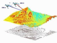
Image: Radar interferometry to produce Digital Elevation Models - this one showing how a pair of images from twin ERS satellites were used to create one of the Etna volcano in Sicily, Italy. Pairs of images acquired from the same spacecraft during different orbits can also be used. Credits: ESA An advanced radar technique to image forests in three dimensions has undergone an ESA-backed test campaign in Indonesia. A future space-based version could measure global biomass to sharpen the accuracy of climate change models.